In the summer of 2023, Mount Cudi is once again the site of significant wildfires, marking a recurring environmental challenge that has profound implications for the region which is an important part of the Kurdish geography. This event brings to the forefront an interview with Zozan Pehlivan, an environmental historian of the modern Middle East, the Ottoman Empire, and Ottoman Kurdistan, conducted in 2020, now translated into English by MedyaNews, that explores the intricate connections between ecology, economy, and history in Turkey, Kurdistan and beyond.
In a 2020 interview for 1+1 EXPRESS, Zozan Pehlivan provides an in-depth analysis of ecological destruction, including deforestation, displacement, and the transformation of socio-economic structures. She draws parallels between historical events such as the 1925 Sheikh Said (Şeyh Sait) rebellion, the 1938 Dersim massacre, and the 1990s displacement of Kurdish villages, connecting them to contemporary environmental issues.
State’s Ecological Apparatus
An interview with Zozan Pehlivan by Anıl Olcan
21 September 2020, 1+1 EXPRESS
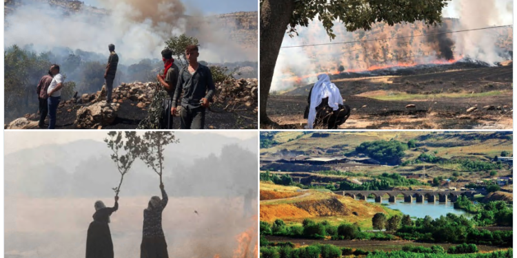
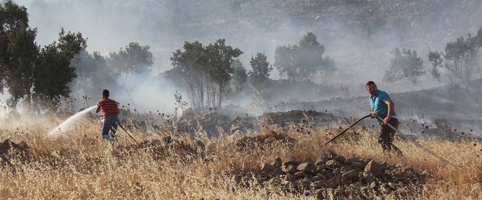
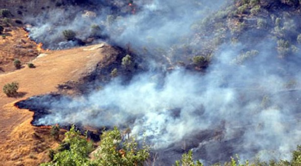
The foothills of Mount Cudi (Çiyayê Cûdî) have been grappling with relentless forest fires for weeks. Fires that cannot be controlled for days in Cevizdüzü (Cifane), Anılmış (Gundikê Remo), Üçkiraz (Nêvava) locations are destroying the habitat of animals and local people, along with trees and vegetation. Villagers desperately trying to protect their crops and animals are attempting to extinguish a vast area with their limited means. So, what do these unquenchable fires tell us? We hear about the ideological, historical, and political dimensions of forest fires from Zozan Pehlivan, a faculty member at the University of Minnesota-Twin Cities and The Harry Frank Guggenheim Distinguished Scholar (2020-21).
The forests on Mount Cudi have been burning for weeks. Why are these fires happening, and what are they leading to?
Zozan Pehlivan: When we talk about Mount Cudi, we are not talking about a very high and rocky terrain. The region is quite extensive and rugged. The dominant vegetation is oak. Oak grows very slowly; its roots go very deep. It holds on to the soil strongly. It prevents erosion and is very important for the richness and sustainability of groundwater. Besides oak, there are other tree species like walnut or wild fruit trees that vary according to altitude, soil type, and microclimate, and lower areas used as pastures and arable land. Mount Cudi and its surroundings, quite suitable for agriculture and animal husbandry, is a region where a large population tries to sustain their lives. Forest fires not only reduce biological diversity and trees but also eliminate all wildlife in the geography, affecting flora and fauna. On the one hand, while global climate change-induced drought is increasing, the increase in forest fires also damages underground water.
People living in the villages around Mount Cudi refer to these fires that are not extinguished for a long time as “practice.”
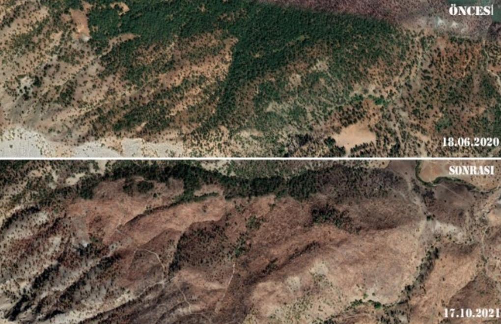
This is an interesting definition. Practice means “work done with a specific logic, strategy, and program.” The characterisation of these fires as “practice” is the result of experiencing systematic politics, and therefore environmental and temporal violence. The story experienced by those living around Cudi and what is reflected in the press are different. While the public perception is a “simple” forest fire news, it is a completely different experience for those living in the region. These people have different dimensions of their relationship with Cudi and its surroundings. On the one hand, they collect and sell wild fruits from the forest, and on the other hand, they collect their firewood for the winter season from dried trees. Collecting dry trees is a good thing for the health of the forest. Collecting dry trees prevents the forest from burning quickly in a potential fire. Also, the villagers graze their animal in the pastures on the outskirts of the forest. The villagers’ life is intertwined with the forest. The distance between the forest area and the villagers’ vineyard and garden is not much. Therefore, the permeability between the vineyard, garden, and forest is very intense. According to the World Forest Fires Database, between 2003-2016, it is seen that fires in the region generally intensify during the July-September period. The duration and affected area of forest fires vary from region to region. Fires lasting three to four days in some areas can last more than 20 days in others. Burning an area for such a long time means ecologically horrific destruction.
“Information from the region indicates that villagers trying to extinguish the fire on their own were hindered for ‘security’ reasons. In this context, we can say that most of the fires were started with a specific mind and imagination, as pieces of a larger ideological engineering plan.”
Is it normal for a forest fire to last this long? Is there no intervention, or can’t there be?
It is possible to answer this question in two ways. But first, we need to define the areas where forest fires intensify. Again, according to World Forest Fires data, the area where fires are most common in the region is the north-east and south-east rural area of Diyarbakır (Amed)-Batman (Elih)-Bitlis (Bedlîs) triangle. The second main area in terms of density is the vicinity of Siirt (Sêrt), Hakkâri (Colemêrg), and Şırnak (Şirnex). Some of these fires may be caused by natural conditions, some to clear agricultural land, and some may be started by security forces. The point to be discussed is how an area is allowed to burn for days. Information from the region indicates that villagers trying to extinguish the fire on their own were hindered for “security” reasons. In this context, we can say that most of the fires were started with a specific mind and imagination, as pieces of a larger ideological engineering plan.
What is the ideological engineering plan you are referring to?
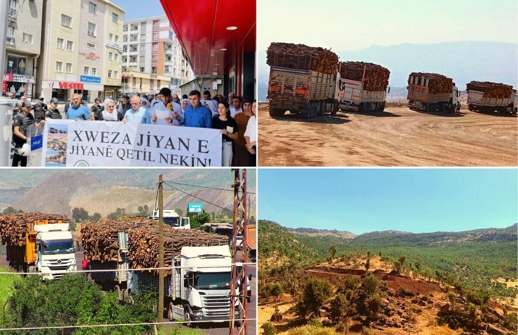
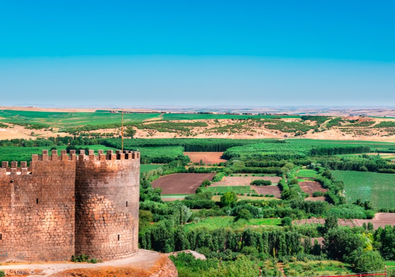
The plight of the villagers victimised by the fires in Cudi and of those being disciplined through power cuts in Mardin (Mêrdîn), along with the violence they all endure, is interconnected. Endless dam constructions, power cuts and forest fires constitute different aspects of the same social engineering project that we cannot view in isolation; instead, they are intricately linked through complex socio-political relationships. This engineering is done by putting ecology at the centre. An incredible number of police stations, or as locally termed, “kalekols*,” have been built in the regions where forest fires have intensified over the last twenty years. Kalekols are built on dominant hills like medieval fortified castles. The forested areas around the hills where they were built were shaved. It was not enough; the forests and pastures around the kalekols were declared security zones, closed to civilian entry. This ideological engineering plan has two goals. The first is to expand the kalekols’ field of vision as much as possible. The field of view in a forested area and a deforested area is completely different. By burning the forest, you are not only clearing the field of view, but you are also eliminating the potential danger that may come from the other side. During the Vietnam War, the USA used heavy chemicals that caused the leaves of plants in forested areas to fall and dry. The second important point is to force migration by making it difficult, even completely preventing, the local population’s access to natural resources. Moreover, by burning the forest, you aim to increase security concerns among the local population, spread the politics of fear by destroying nature.
Are you saying that there is a hot war, a hot conflict environment in the region right now?
As far as reflected in the press, we are going through a period where there are no hot conflicts [in Turkey]. Despite this, forest fires are increasing. The vineyards and gardens of people who returned to their villages during the peace process and planted thousands of fruit trees or started viticulture have turned to ashes. All this picture indicates that what is happening is part of a serious engineering plan. I think one of the goals is to force these people to migrate again.
“Endless dam constructions, power cuts, and forest fires are a social engineering project that we cannot think of as independent of each other and interconnected through complex socio-political relations. This engineering is done by putting ecology at the centre.”
In the regions where the fires are occurring, villagers say they are forced to take their animals to other places to graze. What does this mean?
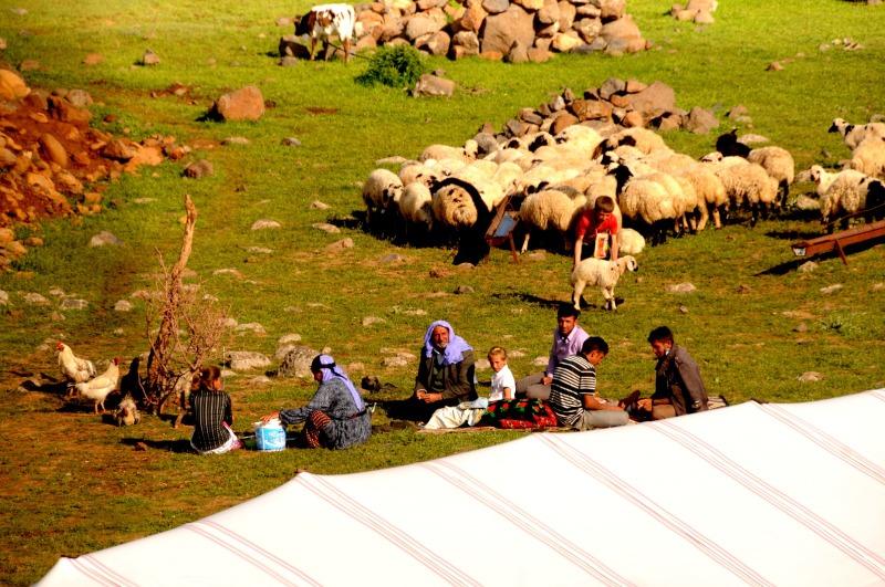
This is a significant risk. Grazing animals is based on knowledge specific to the local geography. Cudi and Gabar Mountain (Çiyayê Gabar) and Faraşin pasture were areas where Kurdish pastoralists grazed their livestock in the 19th century as well. The villager must know, understand, and analyse their surroundings very well. This is not knowledge that forms in three to five years. It’s a matter of transmitting knowledge accumulated over centuries. You need to know basic information like ‘Which land is less rocky, where the animal finds better grass, where there is a water source.’ Due to the fires that have been raging on Cudi Mountain for days, villagers are using different routes to take their animals to graze; if they are using rockier terrain, this carries a risk for the villagers. Especially large cattle do not have the ability to walk on rocky terrain. The animals that can walk on rocky terrain are sheep, goats, and mules. If a cow dies because it is forced to prefer rocky terrain, this is a significant economic loss for the peasant. Also, it’s very important to know if there are poisonous plants in the ‘marginal’ areas that could affect the animals’ lives. The herds of livestock that the villager is economically dependent on are pushed into great uncertainty and danger. Then, of course, there is the security issue. The villager does not know if the herd he takes to graze in the marginal land will be attacked by a pack of wolves or another predatory animal. When you feel insecure, you want to leave where you live. In the ‘90s, many people who were forced to migrate from their villages and lived in the outskirts of big cities, exposed to terrible labour exploitation in textile workshops, want to return to their villages. Some can return. Some of those who return are threatened. The areas that make the peasant economy possible are being destroyed by fires, with the aim of destabilising those regions. The fires are part of a modern depopulation strategy. There are many aspects to this…
What do you mean by the depopulation strategy?
By depopulation, I mean the systematic displacement of the local population from their homeland through a specific policy. The policy implemented today is quite different from the village-burning strategy of the 1990s. When you burn forests, you’re not just burning the forest. There is a whole life connected to that forest. The villager places bee hives in the forest, collects wood for heating. In late spring and summer, fresh oak branches are cut, bundled, and accumulated. These bundles are clustered and then covered with suitable material to prevent them from drying out in the summer heat. Oak leaves are a food source for animals in winter. In the local Zazaki language, this type of leaf is referred to as ‘velg.’ The remaining dry branches are used by villagers for cooking and heating, called ‘perçin.’ The forest is an important energy source for the local people. The areas where the fires occur are also grazing lands. Higher quality grasses in highlands are mowed with the spring months and given to animals in winter. The villagers let the animals graze on grass that is too short to be mowed in the field. When you burn these ecological areas, you are damaging animal husbandry, one of the most important sources of income for an agrarian household.
Does being unable to feed the animal mean the villager has to leave the village?
Being unable to feed the animal directly affects the villager economically, as well as in terms of health and nutrition. An underfed animal not only becomes weak but also become vulnerable to diseases. Serious declines occur in milk and meat productivity. Significant decline occurs in the villager’s income and nutritional sources due to fluctuations in milk production. Additionally, changes in the variety and type of nutrition, i.e., in protein and calcium sources, directly affect their health and physical capacity. In the 16-17th century, Europeans reaching present-day eastern Canada (Newfoundland and Quebec) could not believe the physical splendour of the First Nation [native Canadians]. These tall, strong, and agile natives make Europeans look like a frail and unhealthy race. The physical capacity of the First Nation Canadians is directly proportional to the diversity in their diet. The rich omega they got from seafood, along with the high protein from bison and buffalo, made them healthy and tall. In the 19th and 20th centuries, the average height of the natives, whose rich nutritional sources were destroyed, not only declined incredibly but this people became one of the shortest ethnic groups on earth.
“In the ‘90s, some of the people who were forcibly displaced from their villages are returning. Some of those who return are being threatened. The areas that make the village economy possible are being destroyed by fires, with the aim of destabilising those regions. The fires are part of a modern depopulation strategy.”
What are the different aspects of the depopulation strategy you mentioned?
Let’s look at the power cuts made by DEDAŞ (Dicle Electric Distribution Inc.) in rural neighbourhoods in Mardin at the beginning of July [2020]. DEDAŞ was privatised in 2013. After privatisation, prices are increased at very high rates. According to the data we obtained from the region, villagers are being billed high amounts without any electricity meter, so the amount of electricity used is not disclosed. It is not possible for the villagers to pay these exorbitant bills. Moreover, unpaid bills have been used as an excuse to block the subsidise packages the villager receives from the state through DEDAŞ. Electricity is vital for the villager both in agricultural irrigation and in providing water to animals. If the villager cannot access electricity, both the crops in the field will dry up and die, and the animals will die of thirst. Images of sheep that perished from thirst due to DEDAŞ did not supply electricity in the Mardin region have surfaced on social media. What can the villager do in this situation? They try to generate income by selling the surviving animals for a few pennies and abandon their land. This is a version of forcing the villager to migrate.
You also included dams in the said depopulation practices. Despite years of objections and efforts to prevent it, recently, Hasankeyf was submerged under the waters of the Ilısu dam. Is dam construction a frequently used practice in depopulation policies? How do dams affect the ecological balance?
This is a region where Turkey’s main water sources are located. Dozens of large dams have been built on all branches of the Euphrates and Tigris rivers under the GAP (Southeastern Anatolia Project). The main goal of these dams is to irrigate the northern Mesopotamian plain within Turkey’s borders and open it to commercial agriculture. This is not an agricultural system that feeds the villager and small producer. It’s a system that aims to create industrial agricultural areas that started in the ‘70s and led to the destruction of Thrace under [Turgut] Özal’s leadership in the ‘80s. The state want to open all agricultural lands in the region from Urfa (Riha) to the Botan River to commercial agriculture. It is possible to say that the depopulation policy has transformed according to the global political conjuncture. While there were no such goals until the first half of the 1980s, rural depopulation began in the 1990s. I think that the recent depopulation policy is directly related to the Syrian Civil War that started in 2011. Today’s depopulation policy is also a policy of de-Kurdification of the region. We need to think about this together with the Syrian Civil War and the Rojava Revolution. During ISIS’s attempt to occupy Kobani (Kobanê) in 2015, there was tremendous solidarity on the Turkish side of the border. The governing faction perceived the burgeoning solidarity between two communities, who spoke the same language but were divided by contemporary borders, as a significant threat and chose to bypass it. Therefore, the reflections of the Rojava Revolution in Turkey are related to the strategy of depopulating the lands in the south [of the Turkish border]. After the depopulation policy is completed, I think it is aimed to settle the Syrian refugees, numbering four million, along the entire southern and eastern border from Urfa to the Botan River. Thus, a large agricultural labour force will be obtained, and a demographic barrier will be drawn between the Kurdish population isolated from each other by modern borders.
In your article titled “El Niño and the Nomads: Global Climate, Local Environment, and the Crisis of Pastoralism in Late Ottoman Kurdistan,” you touch upon the ecology of this region… What areas does the region you call Ottoman Kurdistan cover, and what are the features of its ecology?
The geography we refer to as Ottoman Kurdistan starts from the north of Lake Van (Gola Wanê) and extends to the east of Sivas (Sêwaz), and from there to the south of today’s Ras al-Ayn (Serêkaniyê). In the east, we are talking about a vast geography extending to the north of the plains of Hakkâri, Şırnak, Van (Wan), and Mosul (Mûsil). There are mountain ranges surrounding the region, but the entire geography is not mountainous. The eastern wing of the Taurus Mountains, which extend along the Mediterranean, connects to Iran via the Zagros Mountains (Çiyayên Zagrosê) over Hakkâri. The eastern side of the Taurus Mountains cuts through Kurdistan like a crescent. The section of the Taurus Mountains in Kurdistan is not like the mountains extending along the Eastern Black Sea. There are various plains and plateaus at different altitudes between the mountains, as well as many rivers such as Murat (Çemê Murat), Euphrates (Çemê Firat), Tigris (Çemê Dîcle), Batman (Çemê Bedew), and Botan (Çemê Botan), and the deep valleys created by these river beds. We must not forget Lake Van, the crater lakes on Mount Nemrut (Çiyayê Nemrud), and Lake Hazar (Gola Hazar) near Harput (Xarput). Due to the elevations of the Eastern Taurus Mountains, it has vast plains such as Muş (Mûş), Harput, Beşiri (Beşîrî), Palu (Palû), Urfa, and Diyarbakır. In higher areas, there are plateaus extending along the foothills of the mountains. Ahmed Arif says in his poem “Diyarbekir Kalesinden Notlar” (Notes from Diyarbakır Castle):
Açar, / Blooms,
Kan kırmızı yediverenler / Blood-red wild roses
Ve kar yağar bir yandan, / And snow falls on one side,
Savrulur Karacadağ, / Mount Karaca is swept away,
Savrulur zozan… / The plateau is swept away…
In Kurdish, “zozan” means “plateau.” The place Ahmed Arif refers to in the poem is the Diyarbakır plain, located in the lower regions. Since blood-red wild roses are blooming, spring has come to the plain. However, snow is still sprinkling on Mount Karaca (Qerejdax), southwest of Diyarbakır. These verses of Ahmed Arif describe the diversity of the region’s ecology very well. I define the nature of Ottoman Kurdistan as an ecological threshold.

What does ecological threshold mean?
When imagining this region, we should not think of only mountainous terrain. On the contrary, we are talking about a rich geography where plains, river beds, and plateaus coexist. By ecological threshold, I mean a region or geography distinctly differentiating ecologically from another. Ottoman Kurdistan is neither as flat as Central Anatolia nor as mountainous as Western Iran. There are significant differences in elevation between the northern and southern parts. In addition to elevation, we are talking about a region shaped by deep river valleys. The vegetation varies according to these elevations. Therefore, I define it as an ecological threshold.
“Dozens of large dams have been built on all branches of the Euphrates and Tigris rivers under the GAP. The main goal of these dams is to irrigate the northern Mesopotamian plain and open it to agricultural production. This is not an agricultural system that feeds the villager and small producer. It’s a system that aims to create industrial agricultural areas, which started in the ‘70s and led to the destruction of Thrace under Özal’s leadership in the ‘80s.”
In the mid-17th century, [the Ottoman explorer] Evliya Çelebi, who visited the region, speaks of Van’s poplar trees and Bitlis’s grapes. How do the travellers describe the ecology of the region?
In the 19th century, the region was inundated with European travellers. There are many travellers who speak of Van’s gardens, Bitlis’ walnut trees, and Mardin’s vineyards. In “Evliya Çelebi in Bitlis,” a work translated and compiled by Robert Dankoff, the Bitlis section of the Seyahatname (Book of Travels) is presented. Within this, Evliya Çelebi offers a detailed description of Bitlis, and the surrounding areas. He later travels to other regions of Ottoman Kurdistan and in the fourth volume of the Seyahatname, he describes the geography, cultures, and languages of many of these cities, and the taste and abundance of the fruits and vegetables grown in the Hevsel gardens along the Tigris in Diyarbekir, in extraordinary language and at great length. He compares Hevsel to Egypt’s famous Faiyum Oasis. He explains in detail the importance of the Reyhan (purple basil) gardens in Hevsel, its scent, and colour. These areas are also where the famous Diyarbakır watermelons are grown. It is known that there is a very diverse ecological life in these gardens. They host a rich wildlife, from various bird species to foxes. The Hevsel gardens are not only significant agricultural areas that meet the city’s vegetable and fruit needs but also important summer resorts where the people of Diyarbekir spend the hot summer months.
You use both Diyarbekir and Diyarbakır; what does this difference in pronunciation correspond to?
Place names are important both historically and in terms of the memory of various ways people relate to geography. Until 1937, the name of today’s Diyarbakır was Diyarbekir. In earlier periods, it is also called Amid, Amida, Kara Amid. The Armenian name for the city is Tigranakert. When talking about the Ottoman period, I prefer to say Diyarbekir, and for the period after 1937, Diyarbakır.
Were there forests in the region, or has afforestation occurred later?
In the 19th century, Bingöl (Çewlîg), Dersim, Bitlis, Siirt, Hakkâri, Birecik, and the highlands of Tur Abdin were the areas where forests were most prevalent. The primary vegetation here is oak. The type and quality of oak vary according to elevation, climate, and soil type. In lower and drier regions, there are short oak trees, while in higher areas, there are more magnificent oak trees. We know from archival documents that there were forests in the highlands of Hakkâri, though rare.
Can the ecological diversity of the 19th century still be seen in the region today?
When we look at the geographical distribution of the forest in the region today, we can say that it is not much different from the previous century, with the exception of areas affected by large dam construction. These dams do not only store water and generate electricity. They have the capacity to directly affect the vegetation and precipitation regime of the areas where they are built. In the 20th century, the areas around Bingöl and Dersim were where the forests were most concentrated. There were forested areas in the highlands of Siirt, in Lice and Kulp to the northeast of Diyarbakır, in the countryside of Batman, around the Bitlis river, and along the Murat river, which we call Ottoman Harput. We know that there were large forested lands in the countryside of Hakkâri and Şırnak. In the southern parts of Van, there were weeping willows, and in Bitlis and Siirt, there are dense walnut trees. In the Cezire region, particularly near the Habur (Xabûr) and Zap (Zê) rivers, you’ll find a variety of trees including pine, walnut and poplar. Scattered among these are juniper trees, which thrive in certain areas. In the lower, marshy regions, poplar trees are especially common. These trees are not just part of the landscape; they are essential materials in the local construction and transportation sectors. The most eye-catching tree species in the Van gardens described by 19th-century travellers is poplar. Poplar is so common that in the Zazaki dialect of Kurdish, there are quite a few idioms related to the poplar tree. People who move in the direction of the wind like a poplar leaf are called “zey pele hevriri.”
“I think that the recent depopulation policy is directly related to the Syrian war that started in 2011. Today’s depopulation policy is also a policy of de-Kurdification of the region. We must think of this in conjunction with the Syrian civil war and the Rojava revolution.”
Was environmental destruction for security reasons a method used also in the Ottoman era? Does the recent “practice” of setting fire have a historical continuity?
Throughout the 19th century, great wars are taking place. In the 1820s with the Russians, the Bedirxan Rebellion in 1846, the Crimean War of 1854-56, the Ottoman-Russian War of 1877-78, followed by organised pogroms against Armenians in the 1890s, and then the World War I. The region is directly affected by all of these. War means finding food to feed a vast army. You need a large source of livestock to carry the army’s food, cannons, rifles, and equipment. Casting cannons and making cannonballs are directly related to the use of natural resources. Of course, there has been ecological destruction. But I have not come across an event in the archive documents where an entire region is set on fire, as is happening today. Of course, great destruction has occurred in conflict zones, but I have not encountered systematic annihilation. The roots of seeing nature as something that needs to be subjugated go back quite far. The 19th century is the golden age of man’s domination over nature. The apparatus called the modern state is the primary actor in subjugating nature. Especially the construction of dams, the draining of marshes, and the alteration of river beds can be read as significant processes of this domination policy. For example, the roots of Çukurova (Cilician Plain) being one of Turkey’s largest cotton production areas today go back to the 1830s. This region has a significant nomadic population. Opening the region to agricultural production could only have been possible with the transition of nomadic tribes to a settled life. Therefore, the nomads in the region were forcibly settled by Ahmet Cevdet Pasha’s Fırka-i Islahiye** (1865-1866) and its massive military campaign to forcefully resettle the region’s Turkish and Kurdish speaking pastoralists. This was a very bloody process. We know that with the Ottoman’s centralisation and modernisation process, pastoralists were forcibly displaced. This was because the settled agrarian life meant legibility in terms of conscription, taxation and surveillance. From the tax officer to the police, everyone had to know which village to go to. It is very difficult to establish state authority in a geography where communities are constantly on the move. For the organism called the state, nomads are always a headache and are seen as social groups that need to be brought under control. In addition to the nomads, from the middle of the century, there are Chechen, Circassian and Nogay refugees brought to the region. By settling Muslim refugees here, an attempt was made to create labour. Meltem Toksöz describes this tremendous environmental, economic, and demographic change and transformation process in Çukurova, how the population was affected by the draining of the marshes, and how the labour force and socio-economic relations were transformed, in her book “Nomads, Migrants and Cotton in the Eastern Mediterranean: The Making of the Adana-Mersin Region, 1850-1908” in an extraordinary language.
You said this transformation was a “very bloody process”; how did this process transpire, what has happened?
The tent is the home of the nomad. The tents of pastoralists that refuse to transition to settled life were burned by the Ottoman army. It is possible to make comparisons between the violence experienced by villagers whose houses were burned in the 1990s and the tribes that suffered the oppression of Fırka-i Islâhiye in 1865. After the Fırka-i Islâhiye army was formed, it was sent to the region under the leadership of Ahmet Cevdet Pasha in the spring of 1865, and the policy of forced settlement began. Those who resisted were subjected to great violence. With the increase in the population around and on the peripheries of the drained and undrained marshland, the number of deaths from malaria increases incredibly. Looking at Ottoman Kurdistan, I did not come across practices like burning tents in those days. However, from the newspaper reports of the time, we can read that two villages belonging to the Haydaranlı Tribe in Dersim were completely burned in 1909, and the army confiscated the villagers’ large and small livestock. In an article published in the 31st issue (2018) of the Kürt Tarihi (Kurdish History) magazine by Serhat Bozkurt, the details of how and why the villages belonging to Haydaranlı were burned are explained.
Can the early Republic’s practice of burning villages be considered a precursor to the burning of villages in the ‘90s?
Although the motivation for punishment may be similar, the parameters and targets are entirely different. After the Sheikh Said rebellion in 1925, dozens of Kurdish villages accused of supporting the rebellion were targeted. Many villages in the Diyarbekir countryside were not only set on fire, but the male population was also executed by firing squad, and animal herds were confiscated. Of course, nature was also affected by the wave of violence. During this period, not only the centres of the villages were burned, but also the vineyards, gardens, pastures, and forested areas on the peripheries were set on fire. Small and large livestock left in the barns of the burned houses or in the pastures perished. In the journal of Toplum ve Kuram (Society and Theory, issue 9, 2017), Serhat Aslan’s article titled “Kürdistan’da Doğa/Ekoloji Katliamı” (Nature/Ecology Massacre in Kurdistan) provides details of a report describing a military operation carried out in the autumn of 1927. The report states that not only were people killed, but emptied villages were burned and destroyed, and large herds of animals belonging to the villagers were also confiscated. In 1938, a similar massacre occurred in Dersim, and the environmental impact of the bombardments by military aircraft lasted for decades. The geographical, economic, and political dimensions of the village burnings in the 1920s and those that occurred in the 1990s are entirely different.
“I think that after the policy of depopulation is completed, the goal is to settle Syrian refugees, numbering up to four million, all along the southern and eastern border from Urfa to the Botan River. In this way, not only will a large agricultural labour force be obtained, but a demographic barrier will also be drawn between the isolated Kurdish populations with modern borders.”
How?
In 1925 with Sheikh Said and in 1938 in Dersim, attacks were made targeting a specific geographical area. In the 1990s, the geographical scale was very different; in the ‘90s, the entire geography where the guerrilla movement fighting against the state was located was targeted, and the people of that geography were also targeted within a specific plan. The fundamental motivation was the thought, “We need to cut off the rural blood vessels that feed this movement.” What was attempted while cutting off the rural blood vessels was to sever the relationship that people had established with the geography. Here, we see how important “political geography” is. By targeting and destroying the resources and natural environment of the village economy, you are eliminating the conditions that make the villager’s life possible. Moreover, when you set fire to their pastures, forests, and gardens, you are also preventing any possible return there.
The destruction of humans and ecological devastation are inevitably intertwined, aren’t they?
Of course. Although humans see themselves as beings that rule over nature, they are a part of nature. A forest fire, flood or drought not only changes human life but also fundamentally alters political and cultural activities. In Turkey, from the early 1900s to the 1980s, thousands of village names in Armenian, Greek and Kurdish were changed. Not only village names were changed, but names shaping the public space, like station names, were also altered. This was part of the policy of Turkifying Anatolia. A person has a relationship of belonging with geography, with its trees, flowers, animals, and water, that is not merely economic but also emotional. When you lose this relationship, you begin to shed all the identities that make you who you are. The village evacuations in the ‘90s had a purpose like severing the relationship that the people in this geography had established with their own cultures and languages. Severing the relationship between the peoples and their own cultures and languages becomes much more challenging when they continue to reside in their native geography.
What were the economic consequences of this ecological devastation?
Diyarbakir, Palu, Muş, Beşiri, Silvan (Farqîn), and Harput plains were an economic centre that fed the eastern provinces of the Ottoman Empire. It is known that significant amounts of grain, legumes and rice were cultivated in the region. Places where a serious amount of vegetables and fruits were produced, dried and brought to market. Viticulture is highly developed. We are talking about a geography where Kurdish, Arab, Turkmen, Assyrian and some Armenian communities lived as nomads. These people had millions of animals such as sheep, buffalo, cattle, horses, mules, camels. There was a developed economy dependent on animal husbandry. This region was the breadbasket of the Ottoman East. Animals were exported to Syria, Egypt, wheat was sent to Baghdad and Mosul…
Turning our attention to the turbulent 1990s, a period marked by the forced evacuation of villages across the region. Various sources cite differing figures, with some reporting 2,500 and others around 3,300 villages being emptied. This practice had three distinct aspects. Firstly, some of these villages were entirely razed by fire. Secondly, the inhabitants were coerced into migration. Lastly, the areas surrounding the villages were systematically destabilised. The precise number of those displaced remains uncertain, with estimates ranging from two to four million people.
This mass migration had a catastrophic impact on the region’s economic life. Vital agricultural products such as grain, legumes, tobacco, and fruit were abruptly halted. Moreover, the migrating populace owned millions of livestock. Tevfik Güran, in his studies on the early republic’s economy, noted that Diyarbakir alone was home to several million small livestock, including sheep and goats. Between 1991 and 2000, Diyarbakir experienced a one-third reduction in its small livestock population, while in Dersim, the loss rate soared to around 70 percent.
The situation varied across different areas, with each district experiencing unique loss rates. Particularly alarming were the losses in Mardin Dargeçit (Kerboran), where 60% of cattle, 90% of sheep, and over 70% of goats vanished between 1991 and 2000. These staggering figures, highlighted in a 2012 article by Mehmet Gürses, signify a profound transformation in the region’s socio-economic classes, available capital, and production means.
Adding to the complexity of the situation were the animals that could not be sold, such as donkeys. Hundreds of these creatures were left without owners, and stray donkeys approaching police stations at night were killed by soldiers.
Today, our focus is on the fires in Turkey, beginning with the Cudi mountains and extending to Ayvalık, where a vast forested area is ablaze. These incidents are part of a global pattern, with massive forest fires continuing in California, and Australia experiencing weeks of relentless fires last summer. Some are even linking the Covid-19 pandemic to changes in the ecological balance. How do you see the connection between the pandemic, forest fires, and deforestation?
In addition to the forest fires lasting weeks due to global warming, as seen in Australia and California, significant deforestation is happening. This deforestation is driven by various factors, including agricultural land clearing, mining activities, quarries, and construction. An illustrative example can be found in Ayvalık, Turkey, where a fire affected an 80-hectare area. This fire broke out in a location considered for residential settlement or development. Though the cause of the fire is claimed to be related to electricity poles, we often encounter such fires being started with the intention of opening up land for construction. This trend has been increasing in Turkey over the last 15-20 years, closely tied to the construction economy and the relationships between construction companies and the state’s institutional structure.
The issue extends globally, with serious deforestation activities continuing in many parts of the world. In Brazil, the Bolsonaro government is daily converting the Amazon forests into pasture to establish cattle farms and export cheap meat. The loss of ecological diversity in the Amazon is a disaster for the Earth, and surrendering it to the Bolsonaro government’s policies would be a grave mistake. The destruction of the Amazon will have far-reaching consequences, affecting every living being on Earth, either directly or indirectly.
Along with deforestation, there will be a significant decrease in the population of vital creatures, from reptiles to bats. These creatures, whose natural habitats are destroyed, will not only venture into human settlements but will also spend more time in agricultural and livestock areas. This could lead to the introduction of viruses and bacteria from wildlife into human life. In our globalised world, a virus or bacterium can be rapidly transported to any part of the globe. The coronavirus pandemic is a clear example of this phenomenon.
(*) “Kalekol” refers to a specifically fortified type of military outpost or station constructed in the Kurdish regions of Turkey, especially in rural areas. It is a combination of the words “kale” (fortress) and “-kol” from “karakol” (police station). These structures are typically established not only for security control but also for surveillance activities in the surroundings.
(**) The Fırka-i Islahiye, or Reform Detachment, was a special military unit in the Ottoman Empire, established during the late 19th and early 20th centuries. Its primary purpose was to suppress local uprisings, maintain order, and implement “reforms” in various regions of the empire, including the forceful settlement of nomadic tribes.